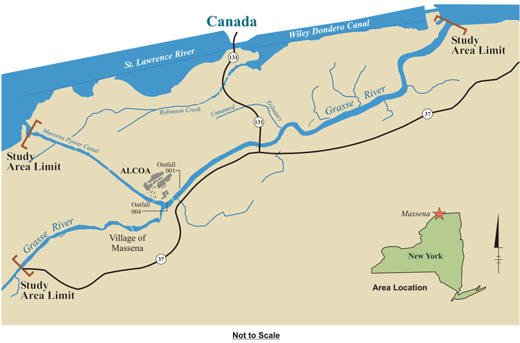
Site Map
The purpose of the Grasse River remediation project is to find the best way to eliminate potential risks associated with the lower seven miles of the river that were caused by historic PCB use at Arconic's Massena West facility (formerly part of Alcoa Massena West) in Massena, NY. For a summary of the project and to read about key project milestones, click one of the following:
The Grasse River is in northern New York State and flows through the Town of Massena before entering the St. Lawrence River. Since 1903, Alcoa has owned and operated a 2,700-acre aluminum smelting and fabricating facility (known as Massena West) situated where the Massena Power Canal and the Grasse River meet. In November 2016 Alcoa successfully separated into two companies - Alcoa Corp. and Arconic. Upon separation, the Massena West forgings and extrusions operation became part of Arconic, which assumed responsibility for the Grasse River remediation project under the ROD issued by USEPA.
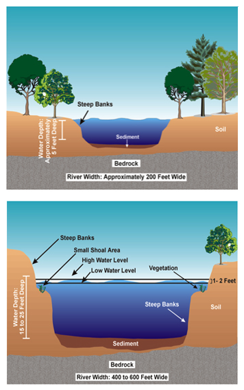
Typical cross sections in the portion of the river near the Village of Massena (top) and in the lower Grasse River (bottom).
About the River
The Massena Power Canal, which connects the St. Lawrence Seaway to the lower Grasse River, and associated powerhouse were constructed in the early 1900s to provide hydroelectric power to the local community and to the "new" aluminum smelting facility. Shortly after its construction, the lower Grasse River was widened and deepened to accommodate the additional flow being diverted from the St. Lawrence Seaway through the Power Canal. The use of the Power Canal for power generation continued over the next several decades to support the growing population in Massena. Operation of the Power Canal ceased in 1958, upon completion of the Eisenhower locks system and Moses-Saunders Power Dam (FDR project) on the St. Lawrence River, which is operated by the New York Power Authority.
The deepening of the lower Grasse River many years ago altered the physical characteristics of the river. The river's banks are steep, and they extend from shallow shoal areas along the shorelines to a relatively deep and flat river bottom that is underlain by bedrock, glacial till or pre-glacial marine sediments. On average, the lower Grasse River is about 400 to 600 feet wide and 10 to 25 feet deep, and has minimal floodplains.
In addition, stopping the water flow through the Massena Power Canal in 1958 significantly reduced the volume of water that is transported through the oversized lower Grasse River channel, which has resulted in low flow velocities throughout the river. Under typical summer flow conditions, flow velocities in the lower Grasse River are generally so low that it can be difficult or impossible to measure with conventional equipment. Even under higher spring flows, flow velocities are still relatively low. These low flow velocities, coupled with the deeper waters that exist in the lower river, create an environment that is favorable for the depositing of solids entering from upstream into the lower Grasse River, making it act more like a reservoir than a river. Because of this, historically, an average of 2 to 3 centimeters of clean solids have been deposited on the river bottom each year. More recent estimates suggest an average rate of about 1 centimeter per year or less.
Studying the River
The sediment deposits in the lower Grasse River have been impacted by the historic discharges of PCBs from the Arconic Massena West (formerly Alcoa) facility. Concurrent with land-based clean-up efforts, the company has conducted numerous studies to evaluate whether the PCB-containing river sediments remain intact during high river flow events. These studies included:
- Measurement of river velocities;
- Comparison of sediment bed elevation measurements collected at different times;
- Development of a hydrodynamic model to predict river velocities during high flow events;
- Study of suspended solids and PCB levels during high flow events;
- Measurement of erosion potential and grain size distribution of the sediments;
- Development of a sediment transport model to predict erosion during high flow events;
- Radiochemistry analysis of finely-sliced sediment cores; and
- Comparison of surface sediment, fish, and water column PCB levels before and after an extreme high flow event that occurred in January 1998.
The results of these studies demonstrate that high flow events (such as a 100-year storm event) have only a small effect on how river sediments move because relatively low velocities exist in the river even under higher flow conditions. Recreational boating activity (e.g., impacts from boat propellers) on the river was also determined to have only a small impact on the river sediments.
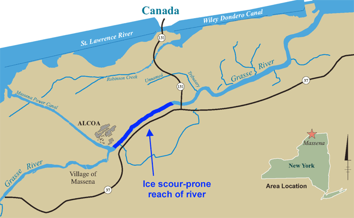
It is important to note these physical characteristics that are particular to this section of the Grasse River because they play a critical role in determining the best way to remediate the river in order to reduce human health risks.